Abstract: With a population of almost 30 million people at risk, Jakarta is one of the Earth’s fastest sinking megacities with some areas sinking up to 25cm per year. (Fleming, 2018). This “sinking” in Jakarta is a result of a combination of pressures including increasing sea levels, increased monsoon flooding, excessive groundwater extraction, and lack of drainage infrastructure (C40 Cities, 2016). It is estimated that Jakarta only has 10 years left before irreversible sinking will begin, resulting in a large portion of the City being under water by 2050 (Fleming, 2018). This irreversible sinking is a result of excessive groundwater extraction and increased urbanization, which is exacerbated by a lack of greenspace and in-situ adaptation for the rising sea levels. By analyzing Jakarta’s future climate change action (CCA) plans and evaluating different adaptation options, a picture of Jakarta’s future emerges. It is one that seems ill-prepared to manage the dire environmental situation, rampant poverty, and required large-scale urban transformation if migration as an adaptation strategy is to be avoided. This paper highlights the need for resiliency in Jakarta’s in-situ adaptation plans, as the future flooding and monsoon conditions cannot be accurately predicted. To determine the best strategy for Jakarta, this paper will evaluate proposed plans based on effectiveness, potential unwanted side-effects, cost, political agreement, ease of implementation, and distribution to existing communities. North Jakarta is flooding faster than other areas, and city planners have written a Sea Defence Wall Master Plan to protect North Jakarta while the longer-term adaptation strategies are implemented (C40 Cities, 2016). Long-term adaptation strategies include management of groundwater, engineering water retention basins, developing biopores (absorption wells), and permanent relocation of coastal settlements (C40 Cities, 2016). Through the implementation of a combination of these plans it is possible that Jakarta can remain habitable through 2050, by slowing its sinking.
Introduction
Jakarta is a flood- prone low-lying coastal city next to the Java Sea (figure 1), on a swampy alluvial plain with 13 rivers flowing through it (Fleming, 2018). Although the geography and sociopolitical scheme of Jakarta seem to be impossible barriers to overcome in stopping the City’s “sinking”, there are in- and ex-situ CCA and DRR plans that have the potential to make Jakarta a habitable city again (Fleming, 2018).
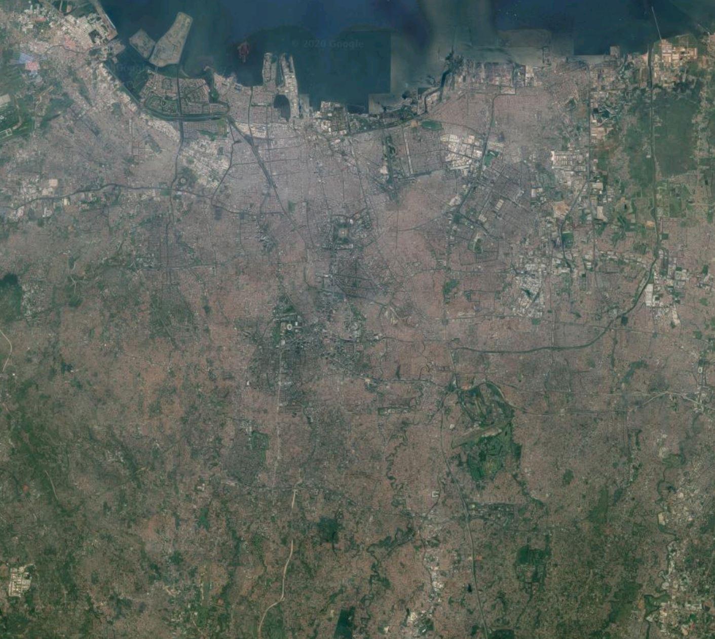
Figure 1. Jakarta’s topography (Google, n.d.).
The rate of sinking of Jakarta as of 2017 was 10cm/year and is projected to reach a total of 1.8m below its base level by 2025 (Varrani and Nones, 2017). As seen in figure 2, the sinking is exacerbated by rising global sea levels, which are impacted by the effects of climate change. The sinking of Jakarta is the result of multiple compounding factors, including groundwater extraction at a rate faster than the recharge rate, and increased physical weight on the land from an increase in population and urbanization. For instance, increased urbanization has increased the burden on the 13 rivers running through Jakarta due to reducing infiltration and increasing runoff rates (Varrani and Nones, 2017).
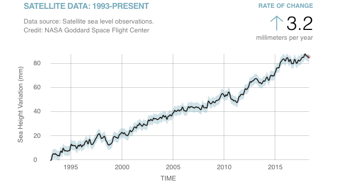
Figure 2. The trend of rising global sea level since 1993, monitored by NASA’s satellites (Fleming, 2018).
The government does not supply or guarantee clean drinking water to locals or businesses but allows digging of wells and water extraction to proceed unchecked (Fleming, 2018). This has led to an overconsumption of ground water when compared the maximum capacity of Jakarta’s aquifers and has also worsened flooding by providing passage for seawater upwelling through the ground (Fleming, 2018). The rising population of Jakarta further increases the urbanization rate while contributing to an increase in the physical weight of the City on its fragile coast. The population increase also exacerbates already problematic water demands, further depleting aquifers and compressing the land (Fleming, 2018). Extraction of fresh groundwater provides the opportunity for increased saltwater intrusion into the aquifers, which poses a threat to the scarce freshwater resources for the City (C40 Cities, 2016). Jakarta’s subsidence occurs as a result of this combination of factors, resulting in additional average sinking of the city of 0.62% per year to 2025, and 0.35% per year to 2050, as shown in figure 3.
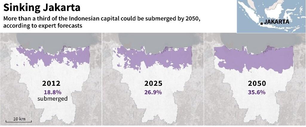
Figure 3. Jakarta’s projected land subsidence (Bandung Institute of Technology).
Jakarta requires immediate and resilient strategies for reducing subsidence for the best chance of avoiding forced migration. These adaptation plans need to be flexible and sustainable by considering the resources that are necessary to build and maintain these strategies. Jakarta lacks the economic and technological resources that are more readily available in developed nation’s coastal cities and will require additional support from outside investors and aid including the Green Climate Fund (GCF) (Varrani and Nones, 2017).
Methods
Jakarta’s various adaptation and DRR plans will be evaluated based on the following criteria: effectiveness, potential unwanted side-effects, cost, political agreement, ease of implementation, and distribution to existing communities. Based on these criteria, recommendations regarding implementation will be made. The plans considered will include:
- Subsidence action plans,
- DRR plans,
- Adaptation plans,
- Jakarta’s Coastal Development Strategy (JCDS),
- Early warning strategies & Jakarta’s Flood Mapping Plan and,
- Migration plans
Throughout the evaluation of these plans, the culture of Jakarta was recognized as a factor that contributed to shaping risk perception as it is built into DRR policies (Surtiari et. al., 2017).
Results
Table 1 indicates the scores for each category of the evaluation. These scores range from a scale of 1 to 5 and indicates ‘least’ to ‘most’ respectively. For example, a rating of 1 under ‘Cost’ means the plan is relatively inexpensive, and a 5 under ‘Ease of Implementation’ indicates that the plan is very difficult to implement.
| Effectiveness | Potential Unwanted Side-effects | Cost | Political Agreement | Ease of Implementation | Distribution to existing communities | |
| Subsidence Action Plans | 4 | 4 | 3 | 5 | 4 | 5 |
| DRR Plans | unknown | unknown | 5 | 5 | unknown | 5 |
| Adaptation Plans | 2 | 4 | 3 | 2 | 2 | 2 |
| JCDS | 2 | 3 | 5 | 3 | 5 | 3 |
| Early Warning Strategies & Jakarta’s Flood Mapping Plan | 4 | 1 | 2 | 5 | 1 | 4 |
| Migration Plans | 2 | 5 | 4 | 1 | 5 | 1 |
Table 1: Evaluation scores for Jakarta’s adaption and DRR plans
Subsidence Action Plans
Jakarta’s subsidence action plan, named the Jakarta Emergency Dredging Initiative, follows a number of steps to stop land subsidence. The plan outlines regulations to limit and eventually stop the extraction of groundwater for consumption (C40 Cities, 2016). To achieve this, the City will provide clean drinking water through pipes, develop proper waste disposal systems, clear canals and vital waterways that are currently backed up with solid waste, construct the East Flood Canal, reconstruct pumps to reduce water levels, and build up the natural coastal defences (C40 Cities, 2016). The natural coastal defences include mangroves, a lagoon, and sea embankments (C40 Cities, 2016). Areas along the coastal floodplain that are currently illegally occupied will also be cleared out (C40 Cities, 2016). The lagoon will be built by cutting off flow from the part of the Gulf where it will be located, as this will help to alleviate flooding by redirecting water into the sea. (Varrani and Nones, 2017). If this plan is followed through in a strict and timely manner, it has the capacity to be effective. Unwanted side-effects may arise if clean drinking water is not distributed evenly and in sufficient amounts. Additionally, the improper planning of digging pipes could add to the structural insecurity of the bedrock and lead to more unwanted side-effects. The plan will have a high initial cost but if successful, it will save more costs in the future. The need to stop subsidence is widely recognized throughout Jakarta, giving this plan the potential to be accepted by residents. For this plan to be executed properly, there needs to be housing options for those being relocated, and access to water needs to be distributed evenly to all communities. This will not be an easy initiative to implement but given the potential positive outcomes, it is a strategy worthy of consideration.
DRR Plans
Indonesia has only recently been working on DRR plans. The Indonesian government made a National Action Plan for DRR (NAP-DRR) with the first draft intended for the years of 2006-2009 and a second for 2010-2012. These were useful for monitoring whether the country was hitting its targets but after 2012, Indonesia decided to integrate DRR into development planning rather than make a third NAP-DRR (Aitsi-Selmi et. al., 2015). After this decision, Indonesia created and joined multiple DRR plans including: the ASEAN Humanitarian Coordinating Centre on disaster management, the ASEAN Agreement on Disaster Management and Emergency Response, Indonesia’s Medium Term Development Plan involving DRR policies, and the National Disaster Management Plan (Aitsi-Selmi et. al., 2015). The Indonesian government collaborated with the World Bank and UNDP to create the Indonesia Disaster Fund (IDF) to determine the allocation of priority funding and quick rebuilding of essential infrastructure. It is required that at minimum, 10% of the funding for DRR goes towards IDF under the regulation of Building Back Better (Aitsi-Selmi et. al., 2015). Building Back Better is a program focused on improving resiliency in tandem with DRR, with a focus on infrastructure, livelihood, and social environment (Aitsi-Selmi et. al., 2015). While this is in progress, there is currently no incentive from the government for public or private investment in DRR and this means that all non-government contributions are currently voluntary (Aitsi-Selmi et. al., 2015). Lastly, Indonesia wrote their Disaster Risk Management Baseline Status Report to work towards the Sendai Framework for Disaster Risk Reduction, from 2015 through 2030 (Aitsi-Selmi et. al., 2015). The completion of this report involved consultation with various stakeholders (i.e. the community, NGOs, United Nations agencies, the private sector, faith-based organizations, etc.) comprised over four meetings, peer-review meetings and a desk review with data analysis and interviews over eighteen months (Aitsi-Selmi et. al., 2015). Indonesia’s DRR plans are hard to track because they are not in the form of the NAP-DRR. They do not clearly explain steps of the plan, it’s difficult to outline the effectiveness, they have unknown side effects, and lack information on ease of implementation. The cost is high, which cannot be fully covered by the IDF. The extensive consultation process helps reduce conflict over the decisions and increases the effectiveness of the plans. The IDF designating 10% of its funds towards Building Back Better ensures the funds will be distributed to the more vulnerable communities that experience the most flooding (Aitsi-Selmi et. al., 2015). To make DRR plans more successful, steps need to be clearly outlined in the National Disaster Management Plan, incentives for private sector DRR investment need to be provided by the government, and this process needs to happen while DRR is still feasible.
Adaptation Plans
The Jakarta Participatory Mapping of Disaster Risk and Preparedness project was initiated to increase public and local governmental awareness on adaptation strategies to proactively manage climate change and associated climatic risks (Ajibade and Egge, 2019). Through the use of geographic information system (GIS) mapping and Open Street Maps, data was collected on the infrastructure and structural integrity of neighbourhoods and buildings throughout Jakarta. The collected data was used for emergency planning, sustainable development planning, and poverty reduction initiatives (Ajibade and Egge, 2019). The Jakarta Disaster Risk Reduction Education Initiative aims to integrate disaster risk reducing cultural and behavioural changes into the educational lesson plans for children in Jakarta to enhance resilience starting at an early age (Ajibade and Egge, 2019). The Jakarta Master Plan was written in 2010 and outlines the spatial planning, infrastructure changes, and flood prevention strategies Jakarta will work towards until the year 2030 (Ajibade and Egge, 2019). The goals of this plan will be achieved through the construction of a “new sustainable city” on recently reclaimed land, resettlement of exceptionally vulnerable coastal regions, infrastructure upgrades, building of a sea wall, provision of vertical housing options (high-rise apartments) for the upper-middle class in North Jakarta, planting of a mangrove and increase of wetland area to directly mitigate flooding of settled areas (Ajibade and Egge, 2019). However, this plan does not specifically outline how these infrastructure improvements will be carried out in regard to building codes or safety standards (Ajibade and Egge, 2019). Additionally, the vertical housing plan should be expanded, as it would also be beneficial for those with the lowest income, who are generally more vulnerable (Ajibade and Egge, 2019). The sea wall is likely to redirect flooding to areas not protected by its 15 mile long span, and disrupt the local fishing economy, potentially destroying the livelihoods of already poor fishers (Ajibade and Egge, 2019). This plan seems to not consider the needs of the majority of the population, those in the low income bracket, who are still at risk of flooding. Additionally, the lack of consultation during this top-down approach could increase social and economic inequalities between its citizens.
Jakarta Coastal Development Strategy
The Jakarta Coastal Development Strategy (JCDS) was created in 2011 to reduce flooding and increase Jakarta’s resilience against increased future flooding as a result of climate change (Varrani and Nones, 2017). The strategy includes coastal protection strategies and enhancing floodwater retention capacity within the city as an adaptation measure (Garschagen et. al., 2018). This strategy has goals set out for the next three decades. The goal by 2020 is to raise the already existing flood prevention structures to increase their effectiveness, while the 2030 goal is to construct an off-shore dike and a lagoon to control strong fluctuations in sea level (Varrani and Nones, 2017). The goal by 2040 is an 8km seawall built offshore, in addition to the already existing seawall, to help reduce flooding and subsidence (Varrani and Nones, 2017). The JCDS was edited after 2011 and renamed the National Capital Integrated Coastal Development Masterplan (NCICD) (Garschagen et. al., 2018). The main goal of the NCICD is to construct the seawall to block the Bay of Jakarta off from the sea, which is “Great Garuda Project” as seen in figure 4.

Figure 4. The Great Garuda Project (Garschagen et. al., 2018).
When the 25km wall is built, it will create a reservoir that can be kept below sea level to allow some fluctuation of the water level without flooding. To keep the reservoir below sea level, a pumping station will be constructed to pump water out at 730 m3/s (Garschagen et. al., 2018). Other goals of the plan include upgrading retention reservoirs, drainage systems, and pre-existing flood protection walls (Garschagen et. al., 2018). The plan is expected to cost around $40 billion USD, which is less than the cost of rebuilding if no actions are taken. Thus, if the plan is implemented properly and in a timely manner, it has the potential to save Indonesia billions of dollars (Garschagen et. al., 2018). The plan aspires to create 350,000 new jobs, build residences for 650,000 people, have the seawall completed by 2022, and provide flood protection until 2080 (Garschagen et. al., 2018). There has been significant conflict over the construction of the seawall, as it is likely to cause environmental degradation in the area, potentially harming fisheries and livelihoods that depend on the sea. The wall may also increase erosion in flooding in nearby areas not shielded by the wall (Garschagen et. al., 2018). The most glaring issue with this plan is that it does not address the land subsidence and without addressing this, the plan will almost certainly not be successful. If land subsidence is addressed, the construction of the wall and all its negative side effects could potentially be avoided (Garschagen et. al., 2018).
Early Warning Strategies and Jakarta’s Flood Mapping Plan
In order to improve disaster preparedness, prediction, and early warning system effectiveness, the Indonesian Disaster Data and Information Management Database was created. Although initiated in 2008, it has still yet to reach its full potential as a result of competition among different regions for high risk status and funding (Wibowo, Surbakti, and Yunus, 2013). This politicization of disaster data has hampered its effectiveness as a resource and the Indonesian government claims it is currently working towards a solution on the issue (Aitsi-Selmi et. al., 2015). Currently, the Ministry of Public Works and Infrastructure is responsible for flood risk monitoring, the Indonesian Agency for Meteorological, Climatological and Geophysics is responsible for the monitoring of climate disaster risks, and the Centre of Volcanology and Geological Hazard Mitigation for the monitoring of volcano risks (Aitsi-Selmi et. al., 2015). The communication between these three agencies is not streamlined or efficient. A possible solution to the problem could be forming a merged department that shares information, which would enable continuous monitoring without duplicated efforts. Another problem was how early warnings released by any of the above ministries were often not written in a publicly accessible manner (Aitsi-Selmi et. al., 2015). In 2008, Indonesia partnered with Germany, USA, Japan, and China to create the Indonesia Tsunami Early Warning System (InaTEWS) (Aitsi-Selmi et. al., 2015). They provide warnings to their own citizens as well as neighbouring countries that may be affected (Aitsi-Selmi et. al., 2015). The website that is available to the public includes information about the earthquakes detected off the coast including the time of the earthquake, its depth, strength, potential to trigger a tsunami and advice to the public if any actions need to be taken (BMKG, 2020). In the case of a tsunami warning, the information is broadcast on television and radio (Aitsi-Selmi et. al., 2015). Jakarta’s coastal defence strategies have not reached their peak effectiveness, but with the collaboration of the previously mentioned monitoring ministries, this could be changed. With this collaboration, the cost would also be reduced. In order to ensure that no communities are left out of the early warnings, radios could be provided to those without them, as well as neighbourhood sirens put in place to signal an incoming tsunami to allow more time for the residents to evacuate.
Migration Plans
Mass migration out of Jakarta is undesirable, considering the fact that it has historically been responsible for 25% of Indonesia’s GDP, is the country’s capital City, and has social and cultural significance to the locals, as well as the potential for a booming tourism industry due to the presence of nearby coastal reefs (Varrani and Nones, 2017). In April 2019, Indonesia announced their plan to relocate their capacity city, which is currently Jakarta, to a new location on the island of Borneo over the next 10 years (figure 5).
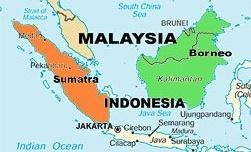
Figure 5. Map showing the migratory distance from Jakarta to Borneo (Wave Foundation).
Indonesia’s decision to relocate Jakarta’s governmental functions and civil servants (along with their families) to a less flood prone island Borneo is an example of a long term adaptation strategy (Van de Vuurst and Escobar, 2020). Theoretically, moving parts of Jakarta to a new location would relieve some of the environmental stresses and reduce flooding. Unfortunately, this process does not include those in Jakarta that are most vulnerable to disaster, those living in poverty, and will increase the likelihood that priority will be given to cover the new cost of partial migration compared to the in-situ adaptation that was scheduled to take place in Jakarta. This plan has other negative impacts including: environmental degradation of Borneo caused by the sudden influx of people, high economic, social, and political cost and potential loss of identity by those who have their family and cultural roots in Jakarta that are told to move (Van de Vuurst and Escobar, 2020). This mass migration is expected to cost at least $33 billion USD (Van de Vuurst and Escobar, 2020). Indonesia needs to continue to support those who are not leaving Jakarta by continuing with the planned in-situ adaptation plans and DRR funding. Additionally, there must be extensive planning and appropriate consultation and development completed to ensure minimal degradation in Borneo.
Discussion
Jakarta is the largest city in Indonesia, and only 2% of the population has access to a sanitation system (World Bank and Australian AID, 2013). Jakarta’s Human Development Index (HDI) is the highest in Indonesia, at a value of 78.39, compared to the Indonesian average of 68.90. The HDI is a measure of living standard, individual knowledge, and personal health (UNDP, 2020). For reference, Canada’s HDI is 92.20, among the highest in the world (UNDP, 2019). This gap in HDI between Jakarta and Indonesia highlights the inequality in resources, governance, social capital, and socio-political cohesion. Although the rest of Indonesia is in desperate need of a DRR plan, resources, and policies, Jakarta is not yet at a level that can be considered desirable or sustainable, and more work is still needed (Aitsi-Selmi et. al., 2015). All but one of the provinces (33 out of 34) have multi-hazard risk assessments with indices of potential losses conducted in collaboration with the Ministries of: Public Works and Housing, Energy and Mineral Resources, Maritime Affairs and Fisheries, Environment and Forest, and Agriculture (Aitsi-Selmi et. al., 2015). If the time and resources are put into all of Jakarta’s subsidence plans, DRR plans, adaptation plans, JCDS, early warning strategies, and Jakarta’s Flood Mapping Plan, it is possible that subsidence and flooding can be stopped, and Jakarta could once again become a sustainable city to live in. Once the Indonesian government announced the plan to move its capital City to Borneo, the other adaptation plans appeared to come to a halt. Caution needs to be taken during the planning process for mass migration as the safety and security of all residents, livelihoods, and communities and environmental protection of Borneo needs to be considered.
Conclusion
DRR assessments in Indonesia continue to lack a strong connection with climate change. Even in midst of relocating their capital city of Jakarta to Borneo, the government needs to focus more how flooding is exacerbated by climate change to ensure environmental degradation does not continue. Overall, Jakarta’s DRR plans have the right intention, but separately no one plan poses a clear solution. By combining the best parts of each plan, a more cost effective, efficient, and equality focused plan can be constructed. Jakarta’s proposed subsidence action plan, the Jakarta Emergency Dredging Initiative is an expensive plan with the potential to cause unintended social and environmental damage. To reduce the risks, and costs, portions of the plan could still be used. By halting groundwater extraction, and building pipes to distribute clean drinking water to all communities; building proper sanitation systems; clearing solid waste from waterways; and building up natural coastal defences, subsidence is reduced, as is the margin for unintended harm. The IDF needs to designate more than 10% of its funding towards Building Back Better, to improve Jakarta’s infrastructure, economy, and social engagement. The Jakarta Master Plan is expensive and protects residents differently based on their income. Though it has good intentions, it would be significantly improved if vertical housing were provided to all those in need because of forced relocation (off of flood plains). The JCDS is focused on stopping flooding, without considering land subsidence. Before funding a $40 billion USD project, more research should go into the plans effectiveness, and potential side effects including causing flooding elsewhere and decreased fishing livelihoods. The Indonesian Disaster Data and Information Management Database can be useful for monitoring flooding; however, its data can be used to determine which regions receive more DRR funding, so regions have been withholding data. Through a more equal distribution of funding, based on environmental assessments and community consultation, regions may be willing to contribute updated information to the database. Indonesia’s migration plan for Jakarta is expensive, does not support the residents in poverty, and has the potential to cause significant environmental degradation of Borneo. The timeline for migration is 10 years, at a cost of only $33 billion USD, which is less than the expected cost of Great Garuda Project. It is likely that the cost of migration is underestimated and will be much greater than expected especially if the plan considers all citizens, strategies for poverty reduction, and plans to assist residents in finding new livelihoods. Jakarta has currently not made a clear statement on which in-situ adaptation plans will remain in progress with the migration plan is in effect. The migration plans will likely take higher political and economic priority over the in-situ adaptation plans, but the needs of the residents in Jakarta cannot be ignored. Instead of halting other DRR plans and attempting to relocate a portion of the City, the migration plan should be considered as a last resort for all residents. Without a clear plan and adequate funding, Jakarta will reach the point of no return and millions of people will lose their homes. The focus should be on making Jakarta a sustainable city, by using aggressive funding and DRR implementation strategies. If Jakarta does “sink” beyond the point of no return, then all resources should be put into the migration plan, which needs to include all residents of Jakarta that want to relocate.
References
Aitsi-Selmi et. al. The Sendai Framework for Disaster Risk Reduction: Renewing the Global Commitment to People’s Resilience, Health, and Well-Being. (2015). International Journal of Disaster Risk Science 6:164-176. DOI 10.1007/s13753-015-0050-9.
Ajibade, I., & Egge, M. (2019). SDGs and climate change adaptation in Asian megacities. Achieving the Sustainable Development Goals: Global Governance Challenges, 100. Retrieved from https://www.researchgate.net/publication/334564225_SDGs_and_climate_change_adaptation_in_Asian_megacities
Alisjahbana et. al. (2010). National Action Plan for Disaster Risk Reduction 2010-2012. State Ministry for National Development Planning, Indonesia.
BMKG. (2020). Indonesia Tsunami Early Warning System (InaTEWS). Retrieved from: https://inatews.bmkg.go.id/.
BMKG. (2020). Indonesian Tsunami Early Warning System (InaTEWS). https://inatews.bmkg.go.id/.
C40 Cities. C40 Good Practice Guides: Jakarta – Coastal Defence Strategy and Flood Mapping. (2016). Case Studies. https://www.c40.org/case_studies/c40-good-practice-guides-jakarta-coastal-defence-strategy-and-flood-mapping.
Fleming, Sean. Jakarta is slowly sinking into the Earth. (2018). World Economic Forum. https://www.weforum.org/agenda/2018/08/jakarta-world-fastest-sinking-city/
Garschagen et. al. Is Jakarta’s New Flood Risk Reduction Strategy Transformational? (2018). Sustainability 10:2934-2952. DOI:10.3390/su10082934.
Google. (n.d.). Google Maps Jakarta. Retrieved July 28, 2020, from https://www.google.com/maps/search/jakarta+elevation+map/@-6.229728,106.6894312,66944m/data=!3m1!1e3.
Japan International Cooperation Agency (JICA). (2012). Master Plan for Establishing Metropolitan Priority Area for Investment and Industry in Jabodetabek Area in the Republic of Indonesia. Coordinating Ministry for Economic Affairs (CMEA). The Republic of Indonesia. Retrieved from: https://openjicareport.jica.go.jp/pdf/12083945_01.pdf.
Kementerian Koordinator Bidang Perekonomian Republik Indonesia. (2014). National Capital Integrated Coastal Development Master Plan.
Kwakwa et. al. (2019). Implementation Completion and Results Report. Jakarta Urgent Flood Mitigation Project (Jakarta Emergency Dredging Initiative). The World Bank.
Maarif et. al. (2010). Indonesia: National disaster management plan 2010-2014.
Republik Indonesia. (2014). Medium-Term Development Plan 2015-2019. Retrieved from: http://extwprlegs1.fao.org/docs/pdf/ins183392.pdf.
Surtiari, G. A. K., Djalante, R., Setiadi, N. J., & Garschagen, M. (2017). Culture and community resilience to flooding: Case study of the urban coastal community in Jakarta. In Disaster Risk Reduction in Indonesia (pp. 469-493). Springer, Cham.
Union of International Association. (2005). ASEAN Agreement on Disaster Management and Emergency Response.
United Nations Development Programme (UNDP). (2019). Inequalities in Human Development in the 21st Century. Human Development Report 2019. Retrieved from: http://hdr.undp.org/sites/all/themes/hdr_theme/country-notes/CAN.pdf.
United Nations Development Programme (UNDP). (2020). Human Development Index. Human Development Reports. Retrieved from: http://hdr.undp.org/en/content/human-development-index-hdi.
United Nations. (2015). Sendai Framework for Disaster Risk Reduction 2015-2030.
Van de Vuurst, P., & Escobar, L. E. (2020). Perspective: Climate Change and the Relocation of Indonesia’s Capital to Borneo. Frontiers in Earth Science, 8, 5.
Varrani, A., & Nones, M. (2018). Vulnerability impacts and assessment of climate change on Jakarta and Venice. International Journal of River Basin Management, 16(4), 439-447.
Wibowo, Surbakti, and Yunus. (2013). Indonesian Disaster Database. Expert Group Meeting, Sendai, Japan. Retrieved from: https://www.unescap.org/sites/default/files/S2-3_Indonesia.pdf. World Bank, Australian AID. (2013). Indonesia Country Study. East Asia Pacific Region Urban Sanitation Review. Retrieved from: https://www.worldbank.org/content/dam/Worldbank/ document/EAP/Indonesia/ indonesia_sanitation_report.pdf.